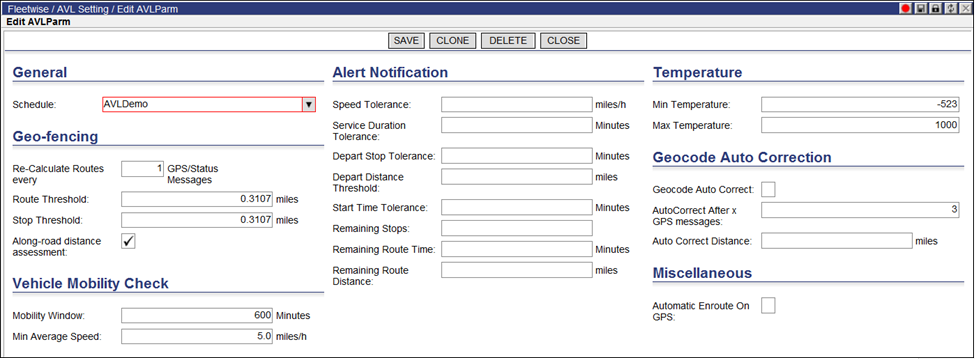
Geofencing configuration is schedule specific. In other words, each schedule key will have its own Geofencing configuration.
To configure geofencing:
1 From the main menu, select Data > Schedule > AVL.

2 Edit the fields in each section as needed. The available configuration options are in six different sections of the page, described below.
3 Click Save to save the configuration, or Delete to delete the configuration.
• Schedule &endash; The Schedule Key that will use this Descartes Automated Vehicle Locator (AVL)/Geofencing configuration.
![]() Note―
The schedule key selected must be of Type-3 or Dispatching Type, otherwise
the Geofencing menu options will not show when right-clicking on a route.
Note―
The schedule key selected must be of Type-3 or Dispatching Type, otherwise
the Geofencing menu options will not show when right-clicking on a route.
• Re-calculate Routes every X GPS/Status messages - This field specifies the maximum number of messages that Descartes Route Planner will use to update Projected Fields in the Route and the Stop when GPS messages are being published to Descartes Route Planner.
• Route Threshold &endash; Radius to utilize as a tolerance for Geofencing on the Route.
• Stop Threshold &endash; Radius to utilize as a tolerance for Geofencing on the Stop.
• Along the Road Distance Assessment &endash; This field specifies whether or not to use the Road Network when calculating the distance between the Reported Longitude/Latitude in a GPS or Status message and the Projected Path of the Route or actual location of the Order.
• Mobility Window &endash; This field specifies the time window during which a vehicle’s average speed is estimated.
• Min. Average Speed &endash; This field specifies the minimum average speed allowed. If a vehicle’s speed drops below the specified minimum average during the specified mobility window time, then Descartes Route Planner will update the route’s AVLStatus to show a Mobility Vehicle Violation.
This section allows the user to set the protocols for receiving automatic alerts as they occur when certain criteria has been met. A value of 0 in any of these fields will turn off the specific notification.
• Speed Tolerance &endash; The maximum time the speed limit can be exceeded before raising an alert.
• Service Duration Tolerance &endash; The maximum time a Service Duration can be exceeded before raising an alert.
• Depart Stop Tolerance &endash; The maximum time a Route stays in a stop that has been completed before raising an alert.
• Depart Distance Threshold &endash; Distance value specifying tolerance for moving activity by a Route. An alert is raised when the route has not reported any movement given the threshold.
• Start Time Tolerance &endash; The maximum exceeding time a route is allowed to delay its start before raising an alert.
• Remaining Stops &endash; This field defines the number (integer) of stops that are in pending before the route is completed. Pending equivalent status include:
Pending
Delayed
Enroute
Skipped
• Remaining Route Time &endash; This field defines the number of maximum number of seconds before a route ends. If the remaining time of the route is less than this number, then an alert is generated.
• Remaining Route Distance &endash; This field defines the number of maximum number of meters before a route ends. If the remaining distance of the route is less than this number, then an alert is generated.
• Min Temperature &endash; This field specifies the minimum temperature allowed. If a vehicle’s temperature drops below the specified minimum average during the specified mobility time window, then Descartes Route Planner will update the route’s AVLStatus to show a Temperature Violation.
• Max Temperature - This field specifies the maximum temperature allowed. If a vehicle’s temperature drops below the specified maximum average during the specified mobility time window, then Descartes Route Planner will update the route’s AVLStatus to show a Temperature Violation.
When validating latitude and longitude from a GPS reading, Geocode Autocorrection is able to take the approximated and actual geocode values and automatically adjust any discrepancies.
• Geocode AutoCorrect &endash; Click the checkbox to turn on Geocode AutoCorrection
• AutoCorrect After x GPS Messages &endash; Defines the number of successful GPS readings before correcting latitude/longitude.
• AutoCorrect Distance. &endash; Defines the distance threshold specifying candidate readings for autocorrection.
![]() Note&emdash;
Once configured, the values in Geocode AutoCorrect, AutoCorrect After
x GPS Messages and AutoCorrect Distance will appear in the columns Auto
Correct Geocode, Auto Correct After x GPS Messages and AutoCorrectGeoDistance
respectively on the AVL List and Location List pages as shown above.
Note&emdash;
Once configured, the values in Geocode AutoCorrect, AutoCorrect After
x GPS Messages and AutoCorrect Distance will appear in the columns Auto
Correct Geocode, Auto Correct After x GPS Messages and AutoCorrectGeoDistance
respectively on the AVL List and Location List pages as shown above.
• Automatic Enroute on GPS